History
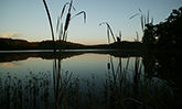
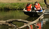
In 1958, land was purchased and plans started to build a dam and spillway for a 65-acre lake. The lake was completed in 1961, and since that time, recreational facilities have been added to provide picnic shelters, toilets, a boat ramp and a concession stand at Randolph County SRA.
Directions
All access to Randolph County SRA is from the west entrance off Palestine Rd. Coming from the North on Route 3, visitors will turn east on Shawneetown Trail south of the town of Ellis Grove. At Palestine, turn south on Palestine Road and proceed two miles, then turn left at the entrance sign. Coming from the north on Route 150, turn west on Shawneetown Trail and proceed to Palestine, then turn south on Palestine Road and proceed to the entrance sign and turn left into the area. Coming from the south from Chester, head north on Palestine Road to the entrance sign and turn right into the area.