Shawnee National Forest - (Scenic Attractions) – 1-800-MY-WOODS
Gambit Golf Club - 1550 State Rt. 146 E, Vienna, IL 62995, (618) 658-6022
Hilltop Campground, (I-57, exit 40), (618) 995-2189
Paul Powell Home (museum) (open Fri. & Sat. 1:00pm – 4:00pm) - Rt. 146 and Vine, Vienna, IL 62995
Chamber of Commerce -Vienna City Park, Vienna, IL 62995, (618) 658-2063
Shawnee Winery - 200 Commercial St, Vienna, IL 62995, (618) 658-8400
Cache River Winery - 315 Forman Ln, Belknap, IL 62908, (618) 658-2274
Shawnee Hills Wine Trail - (618) 967-4006, e-mail: http://shawneewinetrail.com
Natural Features
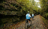
The trail at Harrisburg begins in flat farm country. At New Castle, the old railroad bed enters the Shawnee National Forest purchase area, remaining there for roughly half of the trail's length. By New Brunside, it's among bluffs, and south of Vienna, it passes through a lush wetland. At Karnak, it emerges from the Cache River State Natural Area's ancient cypress-tupelo swamp.
As one landform melds into another, the countryside offers ever-changing vistas. Woodland wildflowers dot the forest floor each spring, while prairie flowers and grasses lend their beauty to the summer landscape. Contrasting with the profuse greenery of summer, the lack of foliage on the oak, hickory, tulip poplar, cottonwood, and sweet gum trees brings the river valleys and rocky bluffs into sharp focus from late fall to early spring.
Wildlife abounds in this section of the state, and Tunnel Hill State Trail offers habitat to a variety of animals. Bluebirds and other songbirds flit through the trees, while killdeer, dove, quail, and wild turkey also are present in the area. Squirrels often are seen scampering among the tree tops, and white-tailed deer are frequently observed. Less noticed, but having a presence, are red foxes, eastern cottontail rabbits, raccoons, and opossums.
Landmarks
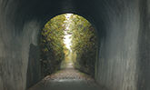
If the 45-mile length of Tunnel Hill State Trail could be seen in cross-section, it would taper to its lowest points at either end, with Harrisburg at 370 feet and Karnak at 340 feet above sea level. The highest point is midway at Tunnel Hill, which has an elevation of 680 feet. By mountain standards, it's just a molehill, but it was high enough that railroad builders decided rather than going over it, they'd tunnel through it, giving the landmark its name. Their decision resulted in a comfortable 2 percent grade for the length of the trail.
For more than 50 years after the railroad was built, the tunnel was longer than 800 feet, but when a portion of the tunnel collapsed in 1929, the landmark was shortened by 300 feet. Now 543 feet long, it is the only tunnel on the trail. The tunnel is located 1/4 mile south of Tunnel Hill on the trail toward Vienna.
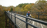
The 23 picturesque trestles along the completed sections of Tunnel Hill State Trail feature decking and side rails, which entice trail users to stop. The trestles range in length from 34 to 450 feet. The longest is the Breeden Trestle, which is also the highest at 90 feet. It is located 2 1/2 miles south of Tunnel Hill.
The trail corridor, which varies from 40 to 200 feet in width, connects numerous communities: Karnak in Pulaski County; Belknap, Vienna, Tunnel Hill, and New Burnside in Johnson County; Stonefort in Williamson and Saline counties; and Carrier Mills and Harrisburg in Saline County. Each has parking areas from which hikers, runners, and cyclists can access the trail.
The parking lot with amenities at Harrisburg is city-owned and maintained. Located in Walnut Street and U.S. Route 45, it is at the northern end of a 2.5 mile-long, city-owned trail. The Harrisburg trail skirts the city's east side parallel to Route 45 and runs to the city's southeast limits, where it connects to Tunnel Hill State Trail at the intersection of Feazel Street.
In addition to the large communities, there also are hamlets along the trail, including Bloomfield, Sanburn and Ledford. In addition, there are a handful of locations that could be described as ghost towns - Forman, Bender, Rago, Parker City and New Castle. All serve as landmarks to trail users. Interpretive signs along the length of the trail point out old coal mines and a sandstone quarry.
Park Office Facilities
Tunnel Hill State Trail is a day-use trail, offering drinking water, privy toilets and parking at the access areas. Motorized vehicles, horses and hunting are not allowed on the trail.
Although an experienced cyclist should be able to travel the complete trail in about a day, hikers are advised that the trail does not have camping facilities. Several campgrounds, however, are located nearby. Shawnee National Forest has three campgrounds within 10 miles of the trail: Lake of Egypt, north of the community of Tunnel Hill; and Teal Pond and Bell Smith Springs, both southeast of New Burnside. A fourth, Lake Glendale , is about 15 miles east of Vienna. Also located in the same vicinity as Lake Glendale is Dixon Springs State Park. Two other state park campgrounds are about 10 miles from the trail: Ferne Clyffe, west of the community of Tunnel Hill; and Saline County Conservation Area, southeast of Harrisburg.
The site office for Tunnel Hill State Trail is located on State Highway 146 on the east side of Vienna. For more information about the trail, contact the site superintendent at Tunnel Hill State Trail, P.O. Box 671, Vienna, IL 62995, or phone (618) 658-2168.