- LaSalle Lake State Fish and Wildlife Area
Park Brochure
- While groups of 25 or more are welcome and encouraged to use the park's facilities, they are required to register in advance with the site office to avoid crowding or scheduling conflicts.
- At least one responsible adult must accompany each group of 15 minors.
- Pets must be kept on leashes at all times.
- Actions by nature can result in closed roads and other facilities. Please call ahead to the park office before you make your trip.
E-Bike Rentals: Adventur-E-Bike Rental now rents bikes at this location. You can also call the concession at (815) 313-9416 for more information.
LaSalle Lake is open for the season, daily 6 am to Sunset. Please call LaSalle Lake in advance if you are planning to be launching a boat to fish (815/357-1608). Access to the lake for boat fishing is contingent on weather conditions our answering machine is updated by 6 a am daily.
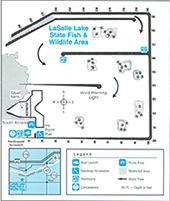
LaSalle Lake, a manmade, 2,058-acre lake 8 miles southeast of Marseilles, is popular among anglers. Serving as a cooling lake for Commonwealth Edison's LaSalle Power Station, the lake is formed by levees that rise above the surrounding land. While this perched construction helps the lake catch the wind to cool the impounded water, it can result in extremely hazardous conditions for unwary boaters.
All lake users should familiarize themselves with the precautions described in the "Safety Information" below.
Dirt excavated for the LaSalle County lake's construction was used to build the shoreline and internal dikes, which are covered with rock riprap. The dikes are used to direct cooling water through a five-day circulation pattern from the discharge channel back to the intake channel. Typically there is a 20-degree water temperature difference between the two channels. The average depth of LaSalle Lake is 15 feet, but excavated areas within the lake are up to 70 feet deep.
With its riprapped shoreline, LaSalle has no natural shoreline for beaching boats. Boaters must allow ample time to boat from the lake's northern shores to the boat ramp area on the southwestern corner.
Directions
Coming from the north, you can take I-39 or Rte #23 or Rte #47 south to I-80. From I-39 and Rte #23, go east on I-80 to the Seneca exit. From Rte #47, go west on I-80 to the Seneca exit. Go south through the town of Seneca across the Illinois River Bridge on Rte #170 to the flashing yellow light at the Mazon/Grand Ridge Blacktop. Turn right onto the Blacktop and go about two and a half miles. The Fish & Wildlife Area entrance will be on the right.
Coming from the east, go west on I-80 to the Seneca exit.
Coming from the west, go east on I-80 to the Seneca exit. Go south through the town of Seneca across the Illinois River Bridge on Rte #170 to the flashing yellow light at the Mazon/Grand Ridge Blacktop. Turn right onto the Blacktop and go about two and a half miles. The Fish & Wildlife Area entrance will be on the right.
Coming from the south, take Rte #23 or Rte #170. If on Rte #23, go to the town of Grand Ridge. In the middle of town, at the school, turn right onto the Mazon Blacktop. Take the Mazon Blacktop past the nuclear plant. The Fish & Wildlife Area entrance will be on the left. If on Rte #170, go north to the flashing yellow light at the Mazon/Grand Ridge Blacktop. Turn left onto the Blacktop, go about two and a half miles. The Fish & Wildlife Area entrance will be on the right.
We hope you enjoy your stay. Remember, take only memories, leave only footprints.
Northwestern Illinois
2651 N. 21st Rd
Marseilles
61341
41.321
-88.711