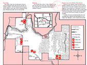
Park Activities
- While groups of 25 or more are welcome and encouraged to use the park's facilities, they are required to register in advance with the site office to avoid crowding or scheduling conflicts.
- At least one responsible adult must accompany each group of 15 minors.
- Pets must be kept on leashes at all times.
- Actions by nature can result in closed roads and other facilities. Please call ahead to the park office before you make your trip.
Area
Bisected by the picturesque river whose name it bears, Mackinaw River State Fish & Wildlife Area provides hunting, fishing, canoeing and an opportunity to interact with nature. The diverse, minimally developed area, consisting of rolling timbered hills and former farmland, is 18 miles west of Bloomington Normal and 3 miles northeast of the town of Mackinaw, between Interstate 74 and Illinois Route 9.
History
The name Mackinaw is a derivative of an Ojibwa word meaning "large turtle." Members of the Hopewell culture lived in the area 1,700 to 2,100 years ago, while the Kickapoo, Potawatomi, Chippewa, and Ottawa also once fished, hunted, and roamed along the river. In the 1960s, a nonprofit Bloomington-based conservation group, the Parklands Foundation, acquired the initial acreage that was to become Mackinaw River State Fish & Wildlife Area. In 1970, the foundation offered it to the state, and subsequent acquisitions by the Department of Natural Resources have brought the total holding to 1,448 acres.
Natural Heritage
The Mackinaw River State Fish & Wildlife Area features a more rugged topography than the rest of the Mackinaw River Valley. The site is located where the Mackinaw River cuts through the Bloomington Moraine, which is a ridge of sand and gravel that was carried and deposited by the Wisconsin Glacier 8,000 years ago. Tributaries to the Mackinaw have cut deep ravines to reach the floodplain, leaving behind high, flat-topped ridges that were used for fruit orchards before they were farmed. Nearly two-thirds of the acreage is forested, which accounts for the abundance of forest-dependent wildlife.
On the upland ridges, a high-quality forest of white oaks and black oaks thrives, while chinquapin oaks, sugar maples, and red oaks dominate the ravines. Sycamore and silver maple occupy the floodplain. Beneath the forest canopy, a lush tangle of native plants covers the forest floor. Birders, wildlife photographers, and other nature observers find Mackinaw an excellent site to pursue their pastimes.
Directions
From the town of Mackinaw, take Illinois Rte 9 east 3 miles to Boston School Road (33500 E), turn left (north), and go 1.5 miles following signs to the site office.
From the city of Bloomington, take Illinois Rte 9 west approximately 20 miles to Boston School Road (33500 E), turn right (north), and go 1.5 miles following signs to the site office.
We hope you enjoy your stay. Remember, take only memories, leave only footprints.
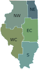
Northwestern Illinois
15470 Nelson Road
Mackinaw
61755
40.554
-89.292