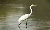
Horseshoe Lake State Park is situated in a low flood plain that follows the Mississippi River to the Kentucky border. Before the present system of levies was constructed, heavy spring floods would cause the river to overflow its banks, sometimes changing directions and cutting a new channel through these bottomlands. During this process, an old river section was cut off from the channel forming a natural oxbow lake.
All lakes, whether man-made or natural, begin to fill in as soon as they are formed. Particles of soil, called silt, are carried in the wind and in water runoff from nearby fields and ditches. Generally, older lakes are more shallow than new lakes. Horseshoe Lake is a very old lake, as illustrated by its average 3-foot depth.
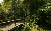
The area that is now Horseshoe Lake State Park has been inhabited by various Native American groups. The earliest evidence of their activity at the site dates to 8000 B.C. during the Archaic Period. Artifacts have also been found which fall into the Woodland period (1000 B.C.-1000 A.D.). During this time, the “Mighty Metropolis” known as Cahokia Mounds was built. Nearby, the 30,000 to 40,000 mound builders farmed extensively, but still relied on Horseshoe Lake’s rich food source. Today, there still remains an earthen platform mound inside the park boundaries.