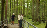
Todd Fink-Heron Pond Trail (1.5 miles) with access at the Heron Pond access area: This easy trail includes a truss bridge over the Cache River and features a floating boardwalk to the middle of Heron Pond’s cypress pond. There are 10 interpretive panels located along the trail.
Little Black Slough Trail (5.5 miles) with access via Wildlife Bluff, Marshall Ridge and Heron Pond areas: Bald cypress and tupelo swamps, sandstone bluffs, floodplain forests and hillside glades highlight this moderately difficult trail that gives hikers passage to Boss Island. A rock ford on the Cache River, difficult to cross during high water, must be negotiated 1.5 miles west of the Wildcat Bluff access.
Lookout Point Trail (1 mile) with access east of the Wildcat Bluff access area: Taking visitors along the edge of a high-quality hillside barrens, this trail provides an overview of the Cache River, its swamps and floodplain forest.
Linkage Trail (2.4 miles) with access via Heron Pond, Wildcat Bluff and Marshall Ridge areas: Linking Heron Pond Trail and Little Black Slough Trail, this easy hike offers a chance to observe the state champion cherrybark oak tree.
Marshall Ridge Trail (2.8 miles) with access via the Marshall Ridge area: Winding through reforested fields, this easy trail connects with the Linkage Trail and provides a gateway to Heron Pond or Little Black Slough.
Tupelo Trail (2.5 miles) with access via Marshall Ridge Trail and access area: This moderately difficult trail begins a quarter-mile north of the Marshall Ridge access area and goes through rolling upland forest to the southern shoreline of Little Black Slough. Excellent views of cypress, tupelo gum trees and swamp exist.
Lower Cache River Swamp Trail (2.5 miles) with access via the Lower Cache River area: Paralleling Cypress Creek and Cache River on a high earthen berm, this trail takes hikers to a cypress and tupelo swamp and is a great place to hear the rhythmic croaking of tree frogs at dusk in the spring. With 3,000 linear feet surfaced in aggregate, much of the trail is accessible year-round, except during periods of flooding. A 1,000-foot accessible trail, located west of the toilet, ends with a viewing platform overlooking the swamp. A 20’ x 28’ picnic shelter is available with privy toilets, water hydrant and drinking fountain.
Big Cypress Tree Trail (250 feet) with access via the Big Cypress area on the Lower Cache River: This short floodplain forest trail takes visitors to one of the bald cypress trees older than 1,000 years and whose base circumference is more than 40 feet.
Section 8 Woods Nature Preserve Boardwalk (475 feet) with access via Section 8 Woods area: Passing through a cypress-tupelo swamp and a floodplain forest, this accessible boardwalk ends with a view of the state champion water tupelo. Along the boardwalk, 10 tree species are identified and there is an interpretive panel on nature preserves and champion trees.
- While groups of 25 or more are welcome and encouraged to use the park's facilities, they are required to register in advance with the site office to avoid crowding or scheduling conflicts.
- At least one responsible adult must accompany each group of 15 minors.
- Pets must be kept on leashes at all times.
- Actions by nature can result in closed roads and other facilities. Please call ahead to the park office before you make your trip.
- We hope you enjoy your stay. Remember, take only memories, leave only footprints.
The Landscape
Totaling 14,960 acres in Johnson, Massac and Pulaski counties, Cache River State Natural Area is composed of three distinct management units - Little Black Slough, Lower Cache River Swamps and Glass Hill.
The Little Black Slough Unit surrounds the Upper Cache River north of the West Eden Road. Nestled deep within the shadowy bottomland forests of this unit lies Heron Pond, a shallow wetland dominated by cypress and tupelo trees. A boardwalk winds its way into the secluded depths of this forested swamp, providing visitors a chance to step back in time and observe wetland and aquatic ecosystems that have remained relatively undisturbed for thousands of years. During the growing season, massive gray-brown cypress trunks arise from a floating carpet of brilliant emerald duckweed. These living pillars of wood extend high over the swamp before disappearing into a shadow-filled canopy. Here, seldom-seen but often-heard bird-voiced tree frogs haunt the leafy branches of tall cypress trees, their melodious calls considered by many to be the most beautiful of all the frog voices. Above and below the water’s surface, birds, mammals, reptiles, amphibians and insects interact in a symphony of survival.
Overlooking the swamps are the low ridges of the Lesser Shawnee Hills. At the base of these hills, bottomland hardwood forests dominated by overcup oak, pin oak, cherrybark oak and sweetgum give way to red oak, white oak and shagbark hickory. Barrens occur on the highest ridge tops where soils are thin and bedrock is exposed. These sites are dominated by small post oak and blackjack oak trees scattered about open expanses of land dominated by grasses and forbs more commonly encountered on dry prairies.
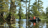
South of the West Eden Road, the Lower Cache River Swamps spread across a broad, flat floodplain between the towns of Karnak and Ullin. The swamps are a mosaic of permanent, deep, open water interrupted here and there by thick-buttressed cypress trees that were old hundreds of years ago. Younger, even-aged stands of cypress and tupelo trees and thickets of buttonbush occur in areas of shallow water. Visitors can experience this lost world while paddling a canoe through 6 miles of trails that meander through rivers, swamps and ponds in a portion of the Lower Cache River known as Buttomland Swamp.
The Glass Hill Management Unit occurs about 3 miles north of Bottomland Swamp near the town of Cypress. An outstanding example of a rare landform called a sandstone knob occurs on this site. All around and on top of this inaccessible knob is relatively undisturbed upland forest dominated by chinquapin oak, red oak, white oak, shagbark hickory and pignut hickory.
Wildlife
The wild places found in Cache River State Natural Area provide food, cover and water for an incredible diversity of plant and animal species, more than 100 of which have been listed as endangered or threatened by the State of Illinois.
If swamps are the Cache River’s signature natural community, then birds are its signature species. Observant birders can expect to see bald eagles, red-tailed hawks, great horned owls, barred owls, great blue herons, great egrets, little blue herons, green herons, least bitterns, wood ducks, mallards, snow geese, sora rails, woodcock, quail, mourning doves, red-headed woodpeckers, pileated woodpeckers, prothonotary warblers, black vultures and turkey vultures. Seasonal migrations bring multitudes of waterfowl and shorebirds to the area, as well as the occasional osprey, golden eagle and black tern.
Mammals often encountered include white-tailed deer, squirrels, raccoons, beavers, gray foxes, red foxes, opossums, skunks and mink. Lucky visitors might catch a glimpse of river otters, bobcats or tiny Indiana bats.
Bird-voiced tree frogs, southern leopard frogs, spring peepers, western chorus frogs, bullfrogs and American toads are among the more vocal of the area’s amphibian inhabitants. Other well-known residents of Cache environs are the cottonmouth, copperhead and timber rattlesnake. While the bite from these venomous species is dangerous, as long as visitors are both cautious and observant, they have little to fear from these reclusive, non-aggressive creatures.
Fishing
Swimming under or on the tea-colored waters of the Cache are numerous fish, amphibians and reptiles. Channel catfish, crappie, bass and bluegill are prized by area fishermen. Less sought after but true swamp fish include the bowfin, needlenose gar, grass pickerel and yellow bullhead catfish. Pygmy sunfish and cypress minnows are two state-endangered fish found only in wetlands dominated by forested swamps.
Barkhausen-Cache River Wetlands Center
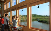
The Wetlands Center was completed in November 2004 and is a high-quality destination point that fosters natural resources appreciation and education, while interpreting the unique natural and cultural history of the Cache River Wetlands. Located south of Whitehill on Illinois Route 37, the center is named for Henry N. Barkhausen, who served as Director for the Illinois Department of Conservation from 1970-73, and for 18 years served as Secretary of the Citizens Committee to Save the Cache River. He worked to encourage government agencies, organizations and residents to protect and restore the natural character of the Cache Wetlands. The Wetlands Center hours and days of operation are Wednesday thru Sunday, 9 a.m. - 4 p.m.
Canoe Trail
The Lower Cache River Trail offers paddlers a quality canoe experience, 3 to 6 miles in length, through magnificent cypress-tupelo swamp. The highlight of the trail is Illinois’ largest, and therefore, state champion bald cypress tree. Like many trees within the Cache River State Natural Area, it is more than 1,000 years old.
Canoeists can begin at the Lower Cache River access area or at a private boat launch ($1 fee) south of Perks. Car shuttles are not necessary. The trail is marked with international canoe symbols and arrows and/or yellow stripes on trees. Canoe maps and fact sheets are available at the site headquarters or wetlands center.
While canoeing the Lower Cache is enjoyable, paddlers should be aware that the Upper Cache River is difficult if not impossible to canoe. Severe bank erosion, which is responsible for trees tipping over and creating log jams, makes canoe portages very frequent.
Bike Trail
The Tunnel Hill State bicycle trail travels through 8 miles of the Cache River State Natural Area terminating at the Henry Barkhausen-Cache River Wetlands/Visitor Center, 2 1/2 miles east of Karnak, Illinois near Rago and Ill. Rt. 37.
From the bicycle trail you can access the hiking trail heads of Heron Pond and Big Cypress access, where you can view a cypress-tupelo swamp and see 1,000 year old trees. At the Barkhausen Wetlands Center, visitors can tour the interpretative exhibits and watch a 12 minute audio visual film on the Cache River wetlands.
Hiking Trails
More than 18 miles of designated foot trails exists within Cache River State Natural Area. Other than Little Black Slough Trail and Tupelo Trail which are considered moderate in difficulty, the trails are easy to walk. A 5-mile segment of the 45-mile-long Tunnel Hill State Trail passes through the region, providing expanded opportunities for hikers and cyclists. Paralleling the Karnak-Belknap Road on its northern side, the Tunnel Hill Trail links Little Black Slough, the Lower Cache unit and the Henry N. Barkhausen Cache River Wetlands Center. Trail length is based on round trip distances. Hiking Trail Fact Sheet and Hiking Trail Map
Hunting
Season hunting programs are offered at the site. For details on seasons and other site-specific hunting regulations please review the Site Hunting Information.
Past and Present
The area’s natural resources have always been important to people living in the Cache River valley. Native Americans found the region rich in wildlife and relied on their expertise in fishing, hunting and trapping for food, hides and furs. The first European settlers arrived in 1803, and, finding the soil too wet to farm, concentrated their efforts on timber harvesting. By 1870, several saw mills were processing timber for lumber, railroads ties, boxes and charcoal. Large-scale drainage and land-clearing efforts began in the early 1900s, eventually bringing thousands of acres of bottomland under cultivation. The State of Illinois acquired the first parcel of Cache River State Natural Area in 1970, following cooperation among private, governmental and commercial groups to conserve this unique natural resource.
Today, a cooperative effort called the Cache River Wetlands Joint Venture Partnership is working to protect and restore a 60,000-acre wetland corridor along 50 miles of the Cache River. Partners include the Illinois Department of Natural Resources, Cypress Creek National Wildlife Refuge, The Nature Conservancy, Natural Resource Conservation Service and Ducks Unlimited, with support from the Citizens Committee to Save the Cache River and Friends of Cache River. The focus is to repair natural ecosystems and provide hunting, fishing, hiking, canoeing and other recreational opportunities, which will promote economic development and tourism.
Scientific and educational use of the area is allowed by permit, issued by the Department of Natural Resources.
For information about the permit, hunting and fishing regulations or the site in general, contact Cache River State Natural Area, 930 Sunflower Lane, Belknap, IL 62908, or phone (618) 634-9678, or the Henry Barkhausen Cache River Wetlands Center, 8885 State Route 37 South, Cypress, IL 62923, phone (618) 657-2064.
Directions
To reach Cache River State Natural Area headquarters from the North, take I-57 south to I-24, go east toward Nashville, get off at exit #14 (Vienna), turn right at the stop sign onto US Rt 45, go south on Rt 45 through Vienna 7 miles. Turn right on the Belknap road for 4 miles to the stop sign in Belknap. Turn right at the stop sign on Main Street and go 2,000 feet and turn right onto Sunflower Lane (past the Belknap Methodist Church). Go north 1 mile to the park office, located in the white metal pole building.
To reach the Henry Barkhausen Wetlands Center from Vienna, go west 5 miles on Route 146 from the intersection of Rt. 146 & US Rt. 45. Turn left (south) on Rt. 37, then proceed 9 miles to the Wetlands Center entrance and follow the signs.