Park Activities
- Cache River State Natural Area Brochure
Park Brochure
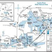
Cache River State Natural Area is situated in southernmost Illinois within a floodplain carved long ago by glacial floodwater of the Ohio River. When the Ohio River adopted its present course, it left the Cache River to meander across rich and vast wetlands. Among the outstanding natural features are massive cypress trees whose flared bases, called buttresses, exceed 40 feet circumference. Many are more than 1,000 years old, including one that has earned the title of state champion bald cypress because of its huge trunk girth, towering height and heavily branched canopy.
The Cache River State Natural Area holds onto some of the highest quality aquatic and terrestrial natural communities remaining in Illinois. Wetlands within this area are so important to migratory waterfowl and shorebirds that in 1996 the Ramsar Convention collectively designated them a Wetland of International Importance, only the 19th wetland in the United States to receive the distinction.
Totaling 18,047 acres in Johnson, Massac and Pulaski counties, Cache River State Natural Area is composed of three distinct management units - Little Black Slough, Lower Cache River Swamps and Glass Hill. They provide food, cover and water for an incredible diversity of plant and animal species, more than 100 of which have been listed as endangered or threatened by the State of Illinois.
The site offers a wide array of recreation opportunities, including hiking, biking, canoeing, fishing and seasonal hunting programs.
Visit the Henry N. Barkhausen Cache River Wetlands Center to learn more about the region's natural wonders.
Southern Illinois
930 Sunflower Lane
Belknap
62908
37.335
-88.938