Goose Lake Prairie was sculpted by glaciers. The flat landscape with its clay-based soils was formed as the last vast sheets of ice melted more than 14,000 years ago. The area became part of a continuous grassland that stretched from Indiana to the Rockies.
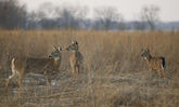
At one time, well over half of Illinois was covered with prairies, earning it the nickname of “The Prairie State.” Goose Lake Prairie, whose original 240 acres were purchased by the state in 1969, now totals 2,537 acres and is the largest remnant of prairie left in Illinois. Buffalo, wolf and prairie chicken once inhabited the area that is now Goose Lake Prairie.
Mound-building groups of Native Americans lived northwest of the area in what is now Morris.
Tribes of the Illini confederation intermittently inhabited the area, hunting and planting corn, squash and beans. They and other Native Americans, including the Potawatomi led by Chief Shabbona, existed with the land, making few permanent changes.
Settlers, relying on the land for their livelihoods, made drastic changes to the area: they planted trees to serve as windbreaks and fences for their farms; in an effort to gain more farmland, they drained the 1,000-acre Goose Lake; they removed the underlying clay, first to make pottery and jugs and later for firebrick; they mined coal beginning in the 1820s and in 1928 began surface mining the land.
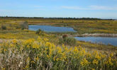
Goose Lake Prairie State Natural Area is a study in contrasts. Tall Grass Nature Trail displays the largest stand of tall grass prairie remaining in Illinois. Many of the park's ponds and marshes resulted from the 1890 decision by local farmers to drain Goose Lake. Prairie View Trail takes you to the highest point in Goose Lake Prairie - a surface mine spoil mound - and offers a panoramic view of reclaimed prairie and prairie marsh and mine areas.