Hours
7 a.m - Sunset
Hike App
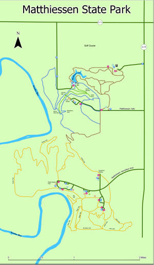
- The restroom building located at the Matthiessen Dells parking lot is currently closed for repairs. Porta-potties are available for park visitors.
- The Lake Falls bridge/trail is closed to all hiking traffic until further notice. A trail detour is posted and available.
- Entrance to each of the interior portions of the waterfall areas such as Lake Falls, Middle Falls, and Cascade Falls is closed as of 7/5/26 due to storm waters and the rising of the Vermillion River.
- Horseback riders: Trails and campground are currently closed. Will open May 1st weather depending.
- The Matthiessen Dells area and Vermillion River Area typically shut down on weekends from May through October when they have reached full capacity (parking lots are full) around 11 a.m. and will not reopen again until 3 p.m.
- Playgrounds and picnic shelters are first-come, first-served.
- Sunflower fields bloom from mid-July through the first week of August for the dove hunting season, located on the back side of the Matthiessen Vermillion River Area. Signs will be posted along Route 178 and the Vermillion River Area entrance road into the park.
IMPORTANT INFORMATION
Park Closures and Information
No Swimming in park waterfalls, creeks, or the River.
Rock Climbing/rappelling is not allowed anywhere in the park.
Bicycles, scooters, skates, and skateboards are not allowed on the trails in the Matthiessen Dells Area. Bike trails can be found at the Matthiessen Vermillion River Area only.
Drones are not allowed at either park.
Metal detecting is not allowed at either park.
It is illegal to possess alcohol at the park.
It is illegal to possess intoxicating substances at either park.
It is illegal to go off-trail or make new trails at either park. Please follow paved trails that are wider than two people and marked with posts, dots on trees, and maps at intersection
NOT ALLOWED FOR YOUR SAFETY, the SAFETY OF OTHERS, and the SAFETY OF THE SITE:
Trails and Trail Map
Canyons, streams, prairie, and forest combine to delight visitors at Matthiessen State Park. Located in LaSalle County, approximately 4 miles south of Utica, and 3 miles east of Oglesby, Matthiessen is a paradise for those interested in geology, as well as recreation. Visitors can expect to see beautiful rock formations in addition to unusual and abundant vegetation and wildlife. All of this, along with park and picnic facilities, make Matthiessen State Park a popular choice for an outing.
 Matthiessen Trail Map
Northwestern Illinois
Box 509
Utica
61373
41.286
-89.025