About Us
Our Mission And Duties
The Office of Water Resources is the lead state agency for water resources planning, navigation, floodplain management, the National Flood Insurance Program, and interstate organizations on water resources. Interagency duties include the state water plan, drought response, flood emergency situation reports, and the comprehensive review of Illinois water use law.
The Division of Resource Management administers regulatory programs over construction in the floodways of rivers, lakes, and streams; construction in the shore waters of Lake Michigan; construction and operation of dams; construction in public bodies of water; diversion and allocation of water from Lake Michigan; and withdrawal of water from Lake Shelbyville, Carlyle Lake, and Rend Lake. Resource Management inspects dams, issues permits, coordinates the National Flood Insurance Program, regulates floodplains and participates in the acquisition of flood prone homes and businesses.
The Division of Capital Program Management assists units of local government with planning, design, construction, and financial assistance in implementing water resource projects dealing with urban flood relief, water supply, Public Water improvements, and infrastructure improvements.
In addition to its normal functions, the Division of Planning gathers water resource data prior, during and following a flood or other disaster. This data is assembled and disseminated to various state and local agencies. Representatives of the Division act as the Technical Liaison to the Illinois Emergency Management Agency (IEMA) and provide daily briefings on flood conditions of monitored streams throughout the state and its boundary waters. In cooperation with the United States Geological Survey (USGS), a summary sheet of river stage information is provided here. Office personnel operate the William G. Stratton lock and dam on the Fox River, the Sinnissippi Dam on Rock River, and other state-owned dams or water control facilities. The office sponsors water resources research and operates stream gauging stations, flood gauges, and lake water stage recorders in cooperation with federal, state, and local cooperators.
Structure of the Illinois Office of Water Resources
The Office of Water Resources consists of the Director's Office and four divisions: Capital Programs, Resource Management, Coastal Management and Program Development. The Director's Office is responsible for the overall management of the Office including policy.
Capital Programs includes the Divisions of Engineering Studies (Stream gaging, Water Supply, Flood Surveillance and Dam Operations), Design & Construction (Contract Management, Design Plans, and Drafting), Technical Services (Field Data Unit, Hydrologic Data and Real Estate Management), and Operations (Inspections, Facility Management and Lock and Dam Operations).
Resource Management includes the Divisions of Northeastern IL Programs, Downstate Programs, Statewide Programs (Mitigation Management, Mapping & CTP Coord, and Mapping & Studies), Lake Michigan Programs Management (Water Allocation), Dam Safety (Dam Safety Engineering), and Levee Safety.
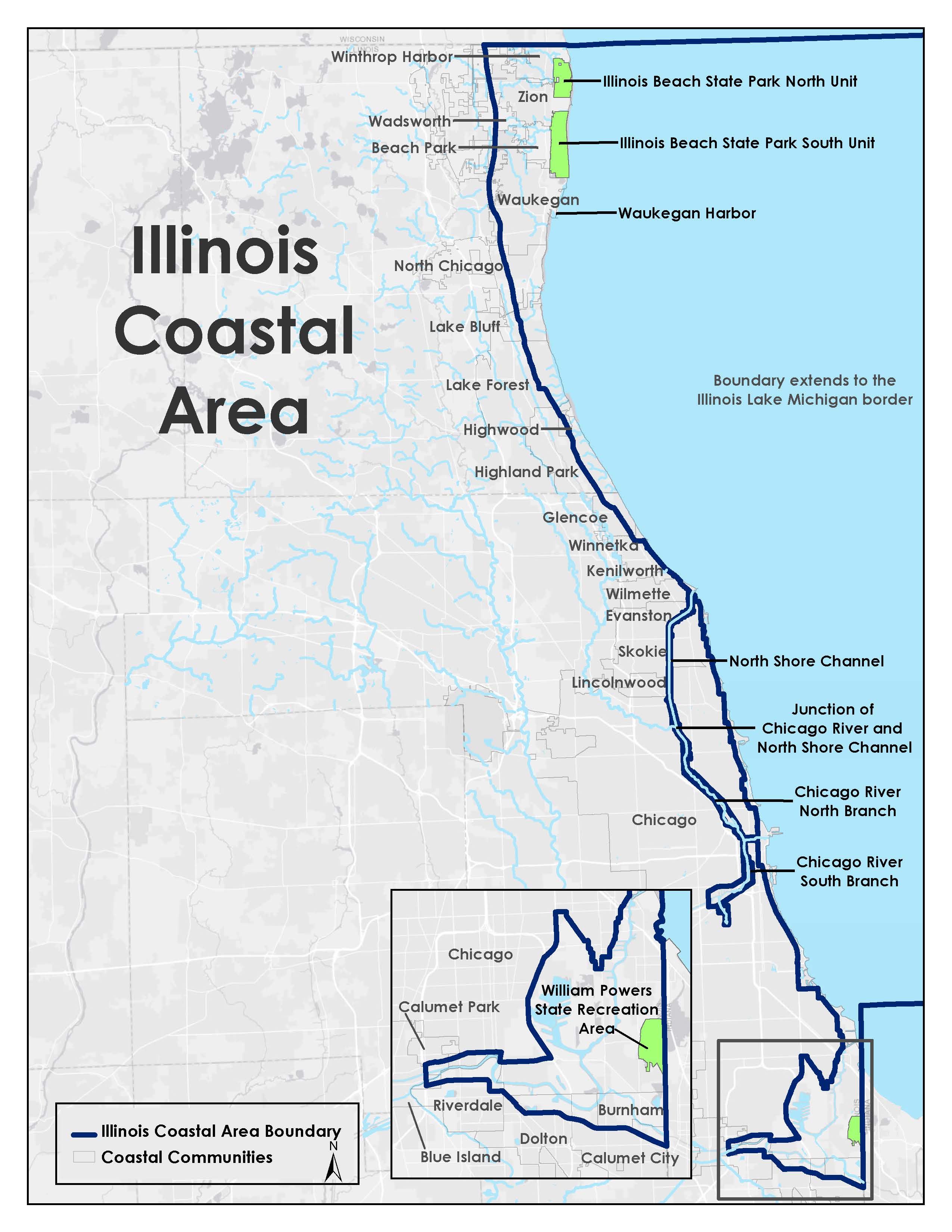
Coastal Management. The Illinois Coastal Management Program (CMP) is a non-regulatory division of IDNR that is dedicated to protecting and enhancing the environmental, economic, and social value of Illinois’ Great Lakes Coastal Region.
Program Development coordinates Office program development, human resource needs, legislation review and development, and funding planning for the Office of Water Resources. Works directly with Federal, State, and local governments in programming and implementation of different elements of the office programs. Tracks and monitors the status of each office division programs, studies, designs, grants, operations, and projects. Provides meaningful input in regard to floodplain management aspects and understanding. Travels statewide to address program related matters. Responsible for analyzing Water Resources related legislation for impacts on current programs. Drafts new legislative proposals when necessary to accommodate Water Resources. Provides testimony relating to the functions of the Division.
History
The Office of Water Resources has a long history beginning with flood control and navigation issues that later grew to include regulation of streams and rivers, locks and dams, construction issues, water conservation, the National Flood Insurance Program and more. It is the oldest Agency within Illinois government.
Early in the 19th century, Illinois was composed of millions of acres of relatively flat swampland due to poor or nonexistent drainage, and lack of protection from flooding. Much of that century was spent in attempts to drain the water off, without much success. The 1850 Swamplands Act gave still unsold lands to the State, nearly 1,500,000 acres worth, and the State passed the lands to the counties expecting drainage benefits, that generally, were not forthcoming.
In 1822 Canal legislation was passed in the young Illinois General Assembly, creating the Board of Canal Commissioners February 14, 1823 with five members. The Board of Canal Commissioners produced a report and was replaced with the first of three Canal Commissions created in 1825, 1829 and 1835. In 1830 the second of these was the first to plat Chicago and Ottawa in 1830. The five members of the 1835 Commission began construction of the I&M Canal in July 1836. The Commission was reorganized in 1837 with three members chosen by the General Assembly.
Financial difficulties in 1845 led to the Canal being turned over to a Board of Trustees until the Canal was financially stable and was then reverted to the State. The Canal was completed and opened for navigation in April 1848. The Canal Trustees submitted their final report in 1871 and returned the Canal to the State of Illinois.
The successor Canal Commission was set up in 1870 and continued until 1917 when the Commission was made a part of the newly created Division of Waterways.
Up until the 1860’s the city of Chicago had dumped its waste into the Chicago River and ultimately into Lake Michigan, but in 1865 obtained permission to pump sewage from the Chicago River into the Illinois & Michigan Canal. By 1881 the canal had become a health hazard and was not working out as a transportation conduit either.
In 1889 the Chicago Sanitary District was formed to build the Chicago Sanitary and Ship canal, the main channel of which was completed in 1900. The Sanitary and Ship Canal extended from the Des Plaines River to the Chicago River’s south branch, causing a reversal of flow in the Chicago River, and diverting Lake water into the Mississippi River system. New sewers fed wastes into the river rather than the Lake. During heavy rains, sewage contaminated waters backed up into the Lake however, which served as the city’s water supply. Later, an additional North Shore Channel was constructed from the north branch of the Chicago River to the Lake.
In past times, the streams of Illinois were used mainly as sources of water supply for man or beast and as highways of transportation and communication. The Division of Waterways' attention soon focused on the inadequate ability of the Illinois Waterway to haul freight competitively, and by 1916 the Illinois and Michigan Canal had very little traffic at all.
A clause to the Constitution in 1870 allowed the State to pass laws regarding drainage and the rights of landholders to build drainage features across their neighbors land, which next year became law. The Act was shortly found to be unconstitutional and rewritten stronger than before in 1879. The Farm Drainage Act of 1885 along with the Levee Act of 1879 form a firm basis for the organization, financing, and operation of drainage districts which quickly came into existence.
By 1920 the number of drainage districts levelled off, the majority forming by 1937. Six and a half million acres were found in 1928 to still require drainage, and that 5,310,000 of these were in the process of being organized.
In 1922, the Sanitary District completed the Calumet-Sag Channel extending the Sanitary and Ship Canal, and reversing the Calumet and Little Calumet Rivers as well as another diversion of lake water into Illinois. Early in the 1920’s the Sanitary District began constructing an extensive system of intercepting sewers and sewage treatment works.
A 1930 Supreme Court decision necessitated a reduction in water taken from the lake. And, the growing city was overloading existing sewer systems leading to backups into tens of thousands of basements. New sewers eased the basement flooding, but led instead to overloaded rivers and the 1954 overflowing into Union Station and the Chicago Daily News building before water could escape via a navigation lock into the Lake. The Calumet and North Branch Chicago River reversed course to overflow into the Lake as well.

The Illinois Legislature created the Department of Purchases and Construction in 1925. Some of the authority formerly vested in the Illinois Waterway Commission was assigned to the newly created Department to enable the design and construction of the Illinois Waterway, with the provision that its powers become void upon completion of the project. The Division of Waterways was thereupon transferred to the new department with the provision for the duration of the waterway project. In 1933 the Department of Purchases and Construction was abolished and the Division of Waterways was again made part of the Department of Public Works and Buildings. Headquarters moved from Chicago to Springfield in 1933.
The Division began the construction of the Illinois Waterway. The Marseilles Lock and Dam when completed was 600 feet long and as wide as the Panama Canal. The new Lockport Lock and Dam had the distinction of having the highest lift of any lock of its size in the world, 41 feet.
The waterway project completed, Waterways turned its attention to surveying the boundaries of Lake Michigan and Wolf Lake, determining the divide between private encroaching lands, and the public lands in holding for everyone. Collection, compilation and dissemination of information on river flow led to agreements with the US Geological Survey to set up stream gaging programs that are still going today. Swampland draining and the creation of drainage districts to reclaim farmlands continued as well. Working with the Corps of Engineers, Waterways was able to increase traffic on Illinois Rivers, making them a major means of transportation in the State. Considerable work was done on general flood protection, particularly in Southern Illinois.
In 1943, highway and all other purely civilian improvements had to be subordinated to more vital national needs for the duration of the war. Approximately 80% of the Division of Waterways' work came under war related activity, including maintenance and operation of 14 movable and 23 fixed bridges on the Illinois waterway between Lockport and Grafton. Much war material was being water-shipped and hundreds of naval vessels built in Great Lakes shipyards (including gigantic submarines) were navigated down the waterway to outfitting ports. Flood control work along the Illinois and Mississippi Rivers, especially in the vicinity of war production industries. Cooperation in solving drainage problems affecting agricultural lands, public utilities and war industries such as channel improvements, and channel changes. Cooperation with State and Federal civilian defense agencies in blacking out bridges, etc. Protection of vital water control structures, such as dams, gates and weirs on various public waters.
In 1945 the Division operated and maintained fourteen movable bridges, navigation aides on twenty-two additional fixed bridges and a ferry at Kampsville. The Division cooperated in maintaining levees and other water control structures along Illinois streams. Approximately 80% of the Division of Waterways' work came under war related activity, including maintenance and operation of 14 movable and 23 fixed bridges on the Illinois waterway between Lockport and Grafton. Much war material was being water-shipped and hundreds of naval vessels built in Great Lakes shipyards (including gigantic submarines) were navigated down the waterway to outfitting ports. Flood control work along the Illinois and Mississippi Rivers, especially in the vicinity of war production industries. Cooperation in solving drainage problems affecting agricultural lands, public utilities and war industries such as channel improvements, and channel changes. Cooperation with State and Federal civilian defense agencies in blacking out bridges, etc. Protection of vital water control structures, such as dams, gates and weirs on various public waters.
Post war projects emphasized flood control alongside the other duties accruing to the Office by statute over the years.
In 1972 the Division was transferred into the Department of Transportation and continued in flood control operations, beginning the Spring & Hickory Creeks Project and becoming involved with the TARP program in the aftermath of the 1986 northern floods.
In 1996 the Office was transferred into the newly created Department of Natural Resources. In addition to navigation, flood control, mitigation, local assistance, dam safety oversight and dam operations, floodplain management and drought duties, the Office participated in dam safety removal programs, ecosystem restoration and aquatic habitat projects.
A History of the Office of Water Resources, By Gary R. Clark, C.E.
A History of Flood Control & Drainage in Northeastern Illinois, By Arlan Juhl, P.E.
Waters and Facilities List
Awards Received